
South Humber planning application (North Lincolnshire)
Site location
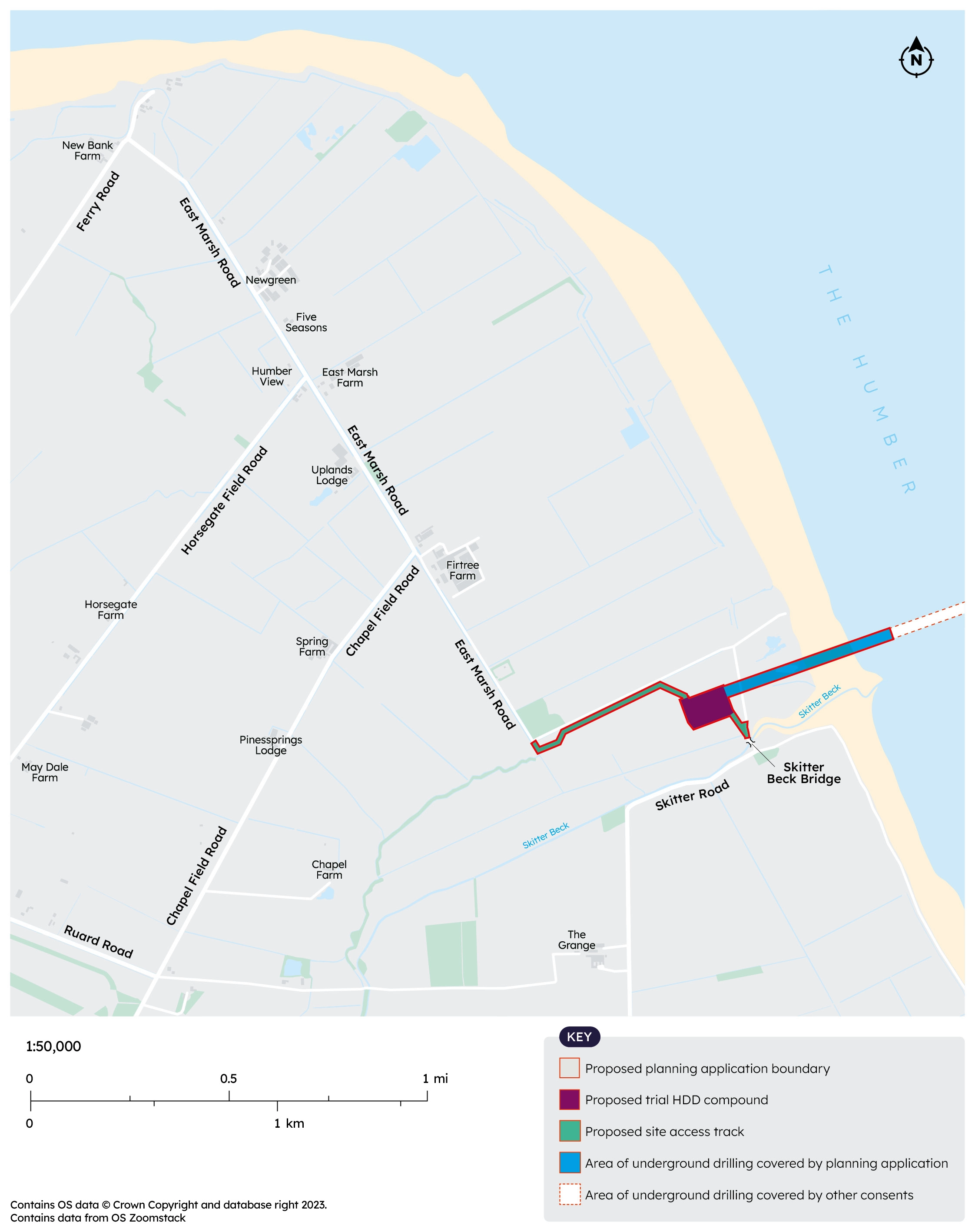
Map 1 shows the location of the proposed compound on the south side. The proposed temporary compound is between East Marsh Road and Skitter Road. It is located away from properties and back from the sensitive estuary habitat.
The map also shows the access tracks we will need to create to connect the compound to East Marsh Road and Skitter Road. The route onto Skitter Road would cross Skitter Beck via East Holland Outfall Bridge which is owned by the Environment Agency.
Map 1
Routes for construction traffic
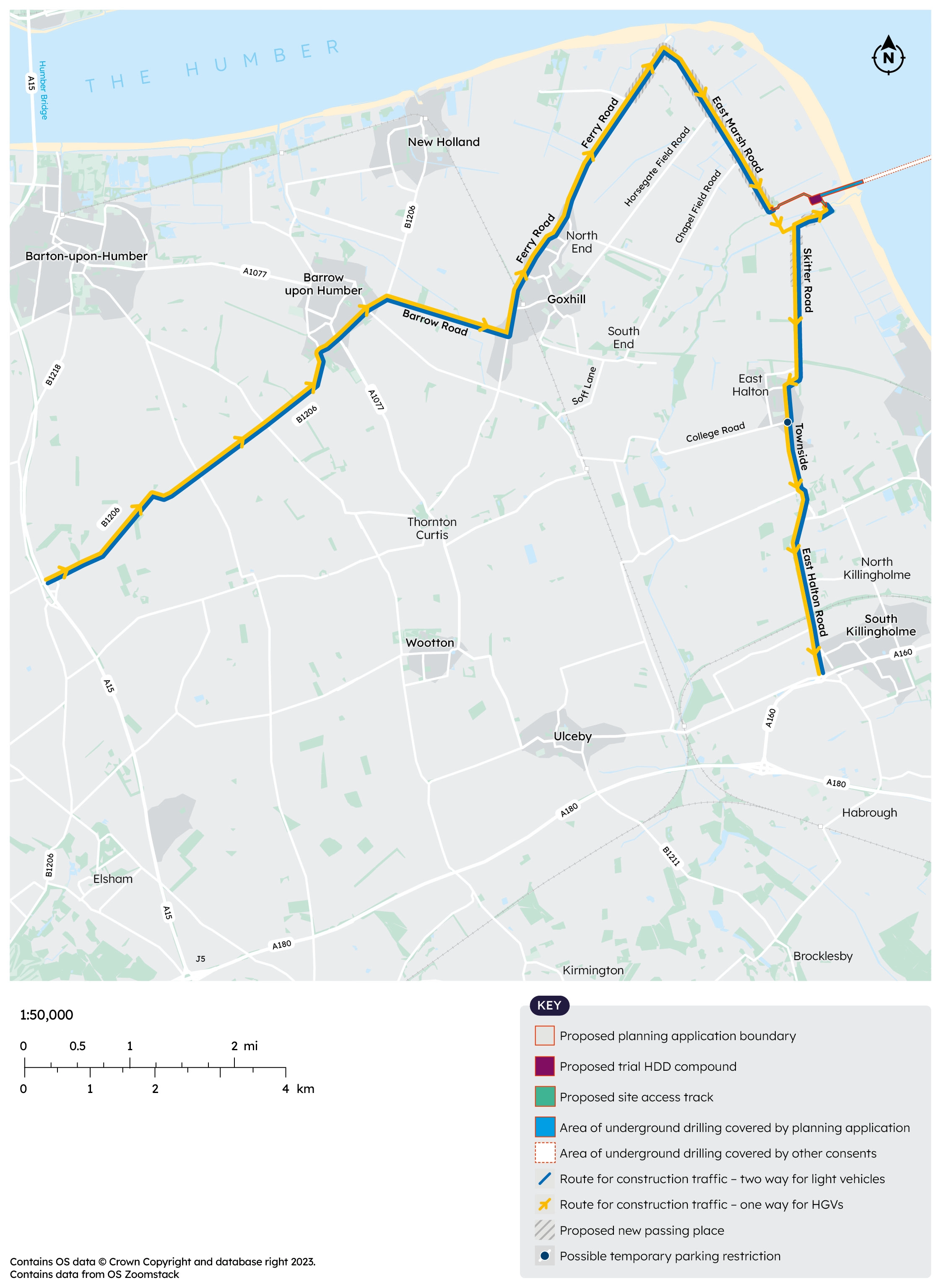
Map 2 shows the proposed routes that construction traffic would use. Heavy Goods Vehicles (HGVs) would typically use a one-way system (applicable to our vehicles only), arriving via the B1206, then Ferry Road and East Marsh Road in Goxhill and leaving via Skitter Road, Station Road and Townside in East Halton. Other light vehicles (cars and vans) would be able to use either route.
Map 2
25 June 2025 update
Please note we have made an amendment to this plan to correct an error. Previously the plan incorrectly showed construction traffic using Barrow Road. However, our intention is to use College Road, as this is the wider of the two routes. This updated plan shows College Road as the proposed route.
North Lincolnshire Council has confirmed that these routes would be appropriate and that HGVs accessing our compound would be legally permitted to route through the Ferry Ward weight restriction zone.
Amount of construction traffic
On an average day we anticipate around 12 HGVs using B1206, Ferry Road and East Marsh Road and 12 using Skitter Road, Station Road and Townside.
Occasionally, for example when we bring in equipment, the number of HGVs may be higher. The maximum number of HGVs per day would be around 23-24 on each route (but we only expect these levels on around 14 days).
On average, 11 light vehicles would also need to access the compound each day; these could use either route. The maximum number of light vehicles on any one day would be 17.
At this stage, the numbers of HGVs include for the possible need to bring in water by tanker. However, we are looking at other water supply options which we hope will help to reduce the number of vehicles.
Improvements to local roads
We plan to install new passing places to allow traffic to safely use the proposed routes. New passing places would be built on the northern end of Ferry Road, on East Marsh Road and on Skitter Road. These areas are shown on Map 2. These may be left in place permanently.
The Project is looking at whether temporary parking restrictions may be required at the junction of Townside and College Road to help keep the junction clear.
Other options considered
The Project has assessed a range of other alternative options and following discussions with the Council, concluded these were not suitable. Routes considered and ruled out include:
- HGVs to use Ferry Road and East Marsh Road in a two-way direction. This option was ruled out because of several pinch points where two HGVs would struggle to pass.
- Chapel Field Road, Churchside and Soff Lane. Again, this option was ruled out because the road is very narrow and two HGVs would struggle to pass.
- Chapel Field Road and creation of a ‘bypass’ avoiding Churchside (as used on previous projects). As this is a short-term trial project it would not be proportionate to reinstate the previously used bypass route, and it would not be possible to have agreements in place before the work needs to be completed. In the short-term putting in place the bypass would also add construction traffic locally. However, this is an option we may look at again for the installation of the full HCCP, if appropriate.
Keep updated
Register here for project updates related to the HDD trial and the Humber Carbon Capture Pipeline.