
The proposed pipeline corridor
The Humber Carbon Capture Pipeline is a proposed underground, onshore pipeline with above ground installations that aims to transport carbon dioxide produced by industrial projects in the Humber region to secure offshore storage under the North Sea.
At this early stage the pipeline has been designed to enable a connection to the consented carbon capture project at Drax as well as to provide connections to the Keadby, Croxton, Killingholme and Salt End areas, to link to carbon capture projects that were shortlisted by the Department for Energy Security and Net Zero (DESNZ) in the cluster sequencing process in August 2022.
The pipeline would enable a connection to any carbon capture projects in the Humber selected by DESNZ. We expect DESNZ to set out a selection process for East Coast Cluster expansion from 2024.
The proposed pipeline corridor has been designed to be away from residential areas and to avoid sensitive locations where possible. It mostly passes through agricultural land; we will be working closely with landowners to minimise disturbance.
The pipeline would have a diameter of up to 66cm. Our plans show a proposed pipeline corridor which is typically 300m wide. This includes areas required for temporary and permanent works. The exact location of the pipeline within this corridor has not yet been determined. We are undertaking surveys and gathering and analysing feedback from stakeholders and landowners to identify the best location for the pipeline. As the project design develops, the width of the pipeline corridor will be reduced.
The proposed pipeline corridor is split below into three sections.
Section 1: Drax to the eastern bank of the River Trent
Section 1 extends from Drax to the River Trent. The western part of this section is within North Yorkshire whilst the middle part is in East Riding of Yorkshire and the eastern part is within North Lincolnshire.
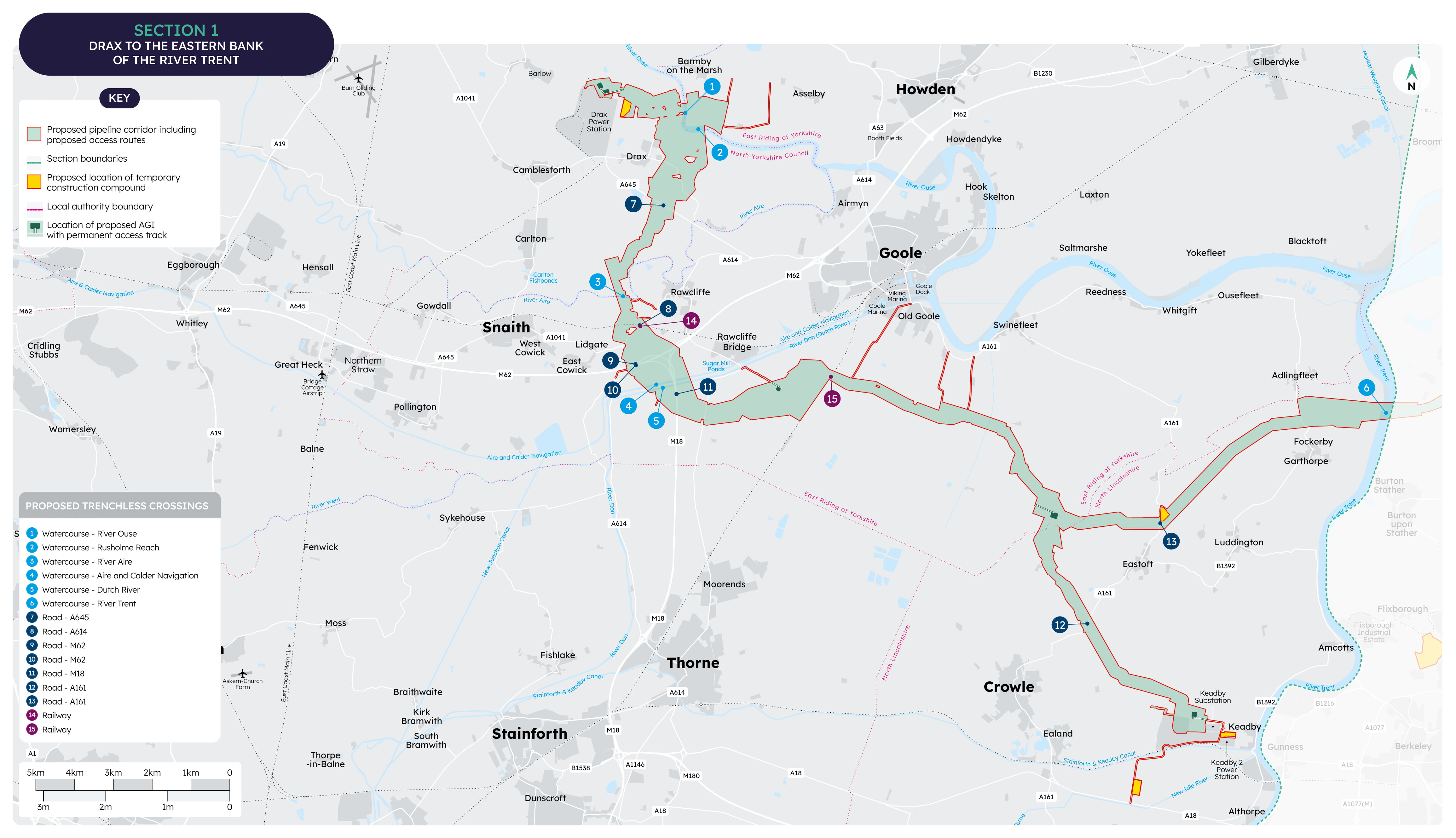
The proposed pipeline corridor starts by providing a connection to a recently consented carbon capture project at Drax, where we are considering two options for the location of an Above Ground Installation (AGI). This area of the proposed pipeline corridor is wider to allow for design development to explore options that minimise the potential impacts to the villages of Drax and Long Drax and the River Ouse.
Continuing south, the proposed pipeline corridor passes west of Rawcliffe and under the Wakefield and Goole railway line, M62, M18 and the River Don. The proposed Humber Freeport – Goole development site constrains the more direct route to the east. An AGI is proposed south of Rawcliffe Bridge.
The proposed pipeline corridor then continues through the agricultural area of Goole Fields. It avoids the River Ouse to the north, and Thorne Moors to the south.
West of Eastoft, an AGI is proposed. A smaller diameter section of pipeline goes to the south to a consented carbon capture project in Keadby. The main pipeline corridor continues eastwards through fields to the crossing of the River Trent between Adlingfleet and Garthorpe, avoiding the Alborough Flats to the north and Burton upon Stather to the south.
Section 2: River Trent to the northern bank of the River Humber
Section 2 is entirely within North Lincolnshire. The proposed pipeline corridor extends from the River Trent to the River Humber and goes north of Winterton, taking into account constraints such as towns, villages, and habitat connected to the River Humber.
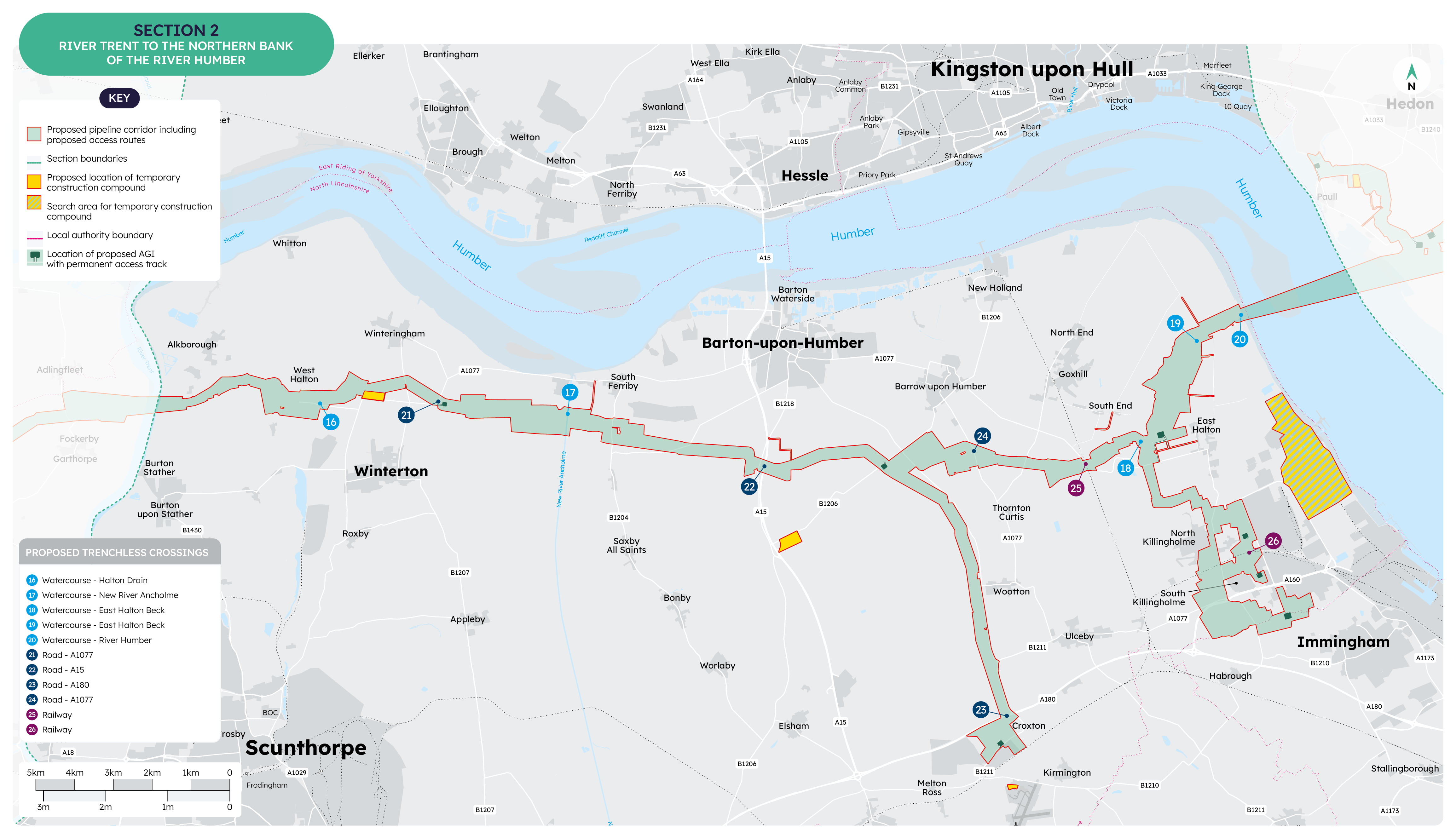
Starting from the west, the proposed pipeline corridor passes south of West Halton and South Ferriby, then crosses under the A15. An Above Ground Installation (AGI) is proposed north of Winterton.
Further east, near Barrow upon Humber, an AGI is proposed. From here, a smaller diameter pipeline goes south passing west of Wootton to an AGI which allows connection to carbon capture projects near Croxton.
The main route continues east, passing under the A1077 and south of Goxhill and South End. Near East Halton, an AGI is proposed, from which the corridor connects to three AGIs that would allow connection to carbon capture projects in the Kilingholme area.
The proposed pipeline corridor continues north, under the River Humber. The corridor avoids the proposed Humber Freeport – Able Humber Port site near East Halton and continues to an area where pipelines already cross the River Humber.
Section 3: Northern bank of the River Humber to the coast north of Easington
Section 3 is entirely within the East Riding of Yorkshire and continues from the north bank of the River Humber near Salt End through to the coast north of Easington.
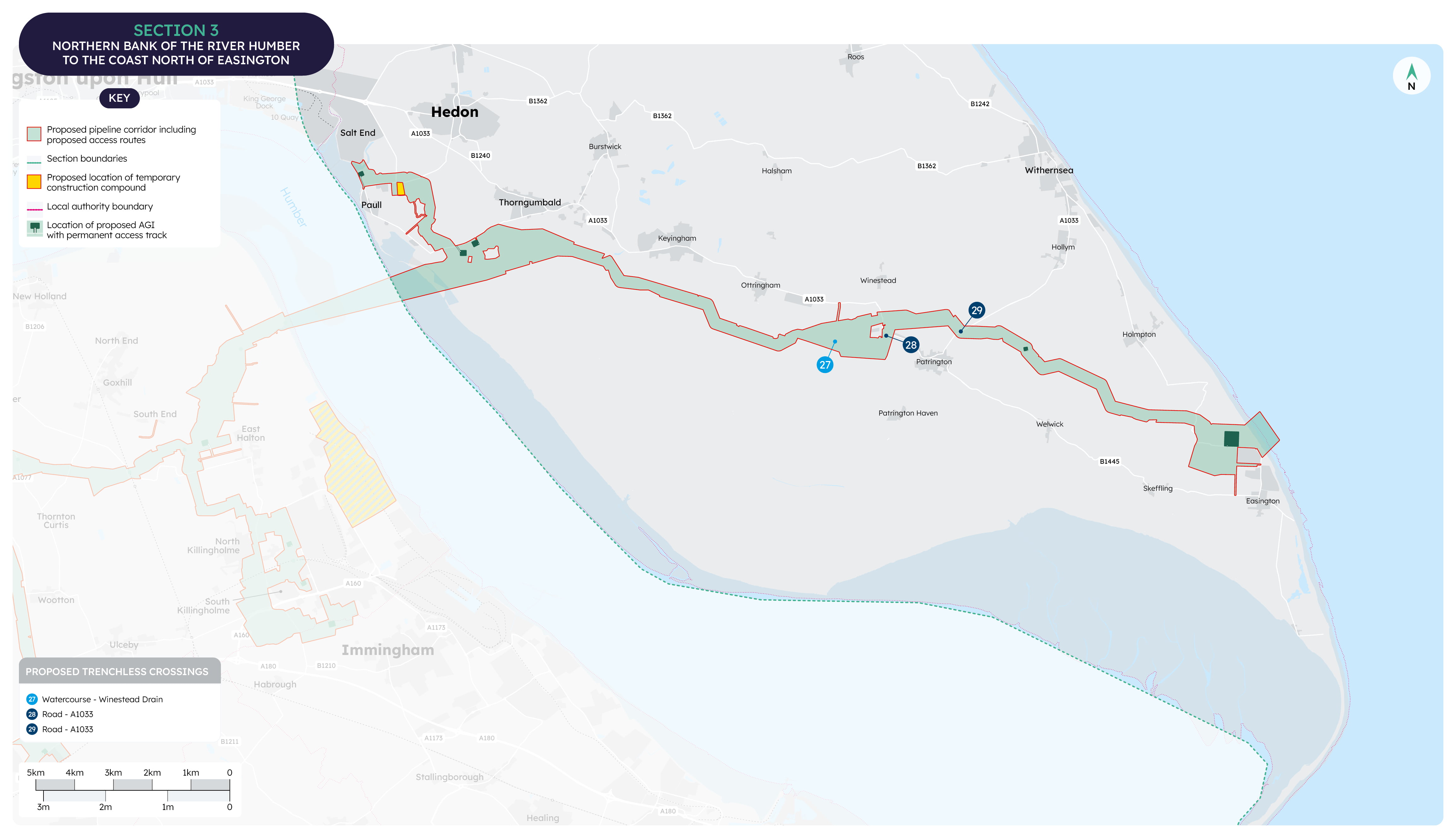
We are currently considering two options for the location of an Above Ground Installation (AGI) south west of Thorngumbald, allowing a smaller diameter section of the proposed pipeline to continue to an AGI north of Paull. This would provide a connection to carbon capture projects in the Salt End area whilst minimising interaction with the proposed Humber Freeport – Hull East.
The proposed pipeline corridor continues eastwards between Thorngumbald and Easington and is positioned to maintain a distance from settlements such as Keyingham, Ottringham and Patrington. An AGI is proposed between Patrington and Holmpton.
North of the village of Easington, the proposed pipeline corridor connects to the pump facility near the existing gas processing site, which will transport the carbon dioxide offshore to the Endurance stores. Beyond this, the pipeline out to sea and other infrastructure would be separately consented and are not part of this proposal.